


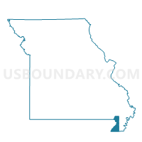
Cardwell Voting District, Dunklin County, Missouri
About
Outline

Summary
| Unique Area Identifier | 607771 |
| Name | Cardwell Voting District |
| County | Dunklin County |
| State | Missouri |
| Area (square miles) | 40.87 |
| Land Area (square miles) | 40.52 |
| Water Area (square miles) | 0.36 |
| % of Land Area | 99.13 |
| % of Water Area | 0.87 |
| Latitude of the Internal Point | 36.04820400 |
| Longtitude of the Internal Point | -90.29387480 |
Maps


Graphs
Select a template below for downloading or customizing gragh for Cardwell Voting District, Dunklin County, Missouri


Neighbors
Neighoring Voting District (by Name) Neighboring Voting District on the Map
- Arbyrd Voting District, Dunklin County, MO
- Buffalo Voting District, Craighead County, AR
- Hays Voting District, Greene County, AR
- Lake Voting District, Greene County, AR
- Neal TWP Precinct 19, Mississippi County, AR
- Senath Voting District, Dunklin County, MO
Top 10 Neighboring County Subdivision (by Population) Neighboring County Subdivision on the Map
- Salem township, Dunklin County, MO (2,932)
- Neal township, Mississippi County, AR (2,566)
- Buffalo township, Craighead County, AR (1,969)
- Buffalo township, Dunklin County, MO (1,383)
- Lake township, Greene County, AR (205)
- Hays township, Greene County, AR (115)
Top 10 Neighboring Place (by Population) Neighboring Place on the Map
Top 10 Neighboring Unified School District (by Population) Neighboring Unified School District on the Map
- Greene County Technical School District, AR (18,658)
- Buffalo Island Central School District, AR (4,967)
- Senath-Hornersville C-8 School District, MO (4,755)
- Southland School District, MO (2,050)
Top 10 Neighboring State Legislative District Lower Chamber (by Population) Neighboring State Legislative District Lower Chamber on the Map
- State House District 76, AR (32,719)
- State House District 162, MO (31,602)
- State House District 77, AR (25,787)
- State House District 79, AR (24,175)
Top 10 Neighboring State Legislative District Upper Chamber (by Population) Neighboring State Legislative District Upper Chamber on the Map
- State Senate District 25, MO (169,588)
- State Senate District 14, AR (91,166)
- State Senate District 11, AR (80,865)
- State Senate District 15, AR (71,063)
Top 10 Neighboring 111th Congressional District (by Population) Neighboring 111th Congressional District on the Map
Top 10 Neighboring Census Tract (by Population) Neighboring Census Tract on the Map
- Census Tract 4806, Greene County, AR (7,307)
- Census Tract 108, Mississippi County, AR (7,108)
- Census Tract 10, Craighead County, AR (4,305)
- Census Tract 4801, Greene County, AR (2,967)
- Census Tract 3608, Dunklin County, MO (2,384)
- Census Tract 3610, Dunklin County, MO (2,116)
Top 10 Neighboring 5-Digit ZIP Code Tabulation Area (by Population) Neighboring 5-Digit ZIP Code Tabulation Area on the Map
- 72450, AR (36,033)
- 63857, MO (12,956)
- 72438, AR (2,574)
- 63876, MO (2,374)
- 72447, AR (1,964)
- 63829, MO (1,120)
- 63821, MO (970)